During the past two weeks, wave after wave of surface low pressures have been spinning up storms over the Arctic Ocean. The impact, especially in the last week, has been breaking up Arctic sea ice, resulting in significant drops in ice extent and area.
While the storms brought cloudiness, they increased wave action and bottom melt which have broken up floes and left them vulnerable to flash melting across large areas.
Here are two views of the Arctic Ocean on August 11, early in the storm process, one from EOSDIS Worldview GCOM-W1/AMSR2 imagery and the other from Polar View from the University of Bremen.
Source: EOSDIS Worldview
Source: Polar View, University of Bremen: http://www.iup.uni-bremen.de:8084/amsr2/Arctic_AMSR2_nic.png
Both depict from breaking up of the pack typical of August, but much ice seems to be relatively ready to survive until the September minimum concentration and area.
However as the storms wound up, causing wind-driven rotation of the pack, wave action began shattering floes and bringing the ice in contact with warmer subsurface water stirred by wave action resulting in continued melt.
By August 22, these effects were obvious, with the sea ice arm stretching into the Laptev, East Siberian and Chukchi seas dispersing and melting as it turned. In addition the "bite" into the heart of the pack continued to deepen.
Source: EOSDIS Worldview
Source: Polar View, University of Bremen: http://www.iup.uni-bremen.de:8084/amsr2/Arctic_AMSR2_nic.png
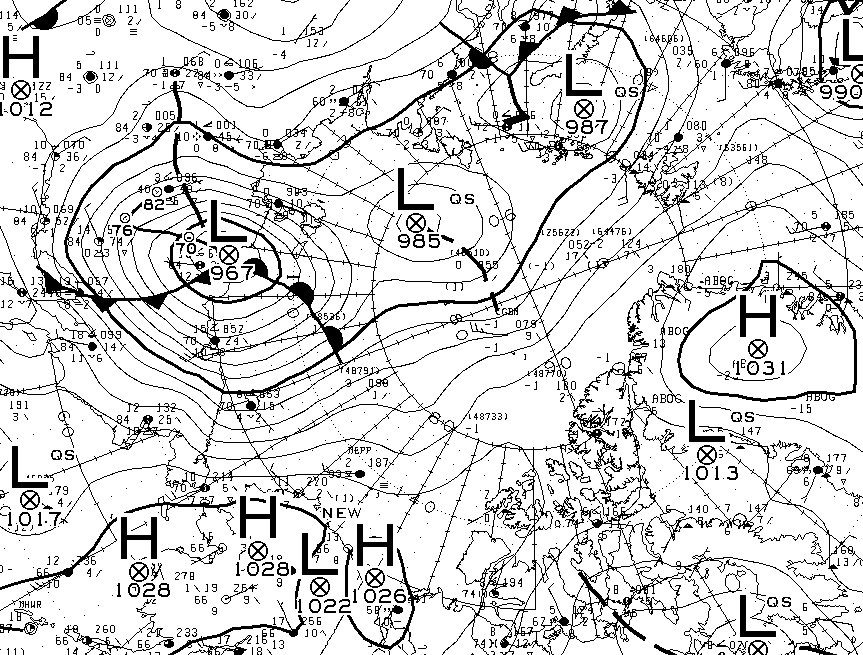
During the last week, continually reinforced surface low pressure centers have gone as low as 967 mb, like this storm center emerging from the Siberian coast August 27th.
Source: Environment Canada
The higher waves and swells have occurred and are forecast to be as high as 2-3 meters near the storm center, which is currently expected to remain about 970-972 millibars in strength for the next 18 hours.
Source: Environment Canada
August 28 observation of Arctic SLP and wind flow.
Forecast August 28, 2016 0000z Source: Environment Canada
The impacts of wave, wind and ocean warmth are apparent in the August 27 imagery. The "Wrangel Arm" has withered and the breakup of ice extends well into the remaining pack. Additionally the flow along Greenland's coast and into warmer waters by some of the pack will lead to further drops in area and extent through September until the minimum.
Source: EOSDIS Worldview
Source: Polar View, University of Bremen
The inflow into the storm center continues to draw in warm moist air which accelerates melt. Winds as high as 30 knots are flowing almost to the North Pole, and flushing ice into warmer waters of the North Atlantic.
Source: Earth Nullschool
While it is quite unlikely we will break the 2012 lows, it seems 2016 is on its way to breaking 2007's extent and area hold on second place.
Source: Arctic ROOS http://arctic-roos.org/observations/ice-area-and-extent-in-arctic
Source: Arctic ROOS http://arctic-roos.org/observations/ice-area-and-extent-in-arctic
Who knows what the rest of this Arctic melt season has in store, but the mix of higher sea surface temperatures, storms and waves may slow sea ice development and lead to another low sea ice maximum next spring.
Sources: Coral Reef Watch 5km SST Anomaly and Climate Reanalyzer Sea Ice. August 26-27, 2016.
The image gives a glimpse of the global climate "heartburn" this incredible year has brought.
The ESRL Global Monitoring Division global CO2 report released August 5th places us again in record territory for CO2 levels, but even worse - with record increasing rates of release.
Source: http://esrl.noaa.gov/gmd/ccgg/trends/global.html
A longer time base depicts the ever increasing trend of atmospheric concentration experienced since 1980.
Source: NOAA ESRL: ftp://aftp.cmdl.noaa.gov/products/trends/co2/co2_mm_gl.txt
June 2016's global average of 403.57 ppm is 3.78 ppm above June 2015, a record year to year increase, surpassing September 1998's 3.58 ppm increase, and July, 2013's increase of 3.48 ppm.
It is this ongoing increase of CO2 rates of concentration that creates sobering concern for our future.
For example, in 1998, the months of August to October recorded increases of more than 3 ppm over prior year. June to August, 2013, also were months experiencing more than a 3 ppm jump over the prior year.
However, in 2016 every month - January to June - has had a year to year increase of over 3 ppm, culminating in June, 2016 with the new record increase of 3.78 ppm, something never witnessed in the ESRL data.
| Year |
Month |
CO2 ppm |
1 Yr Chng |
| 2016 |
1 |
402.32 |
3.02 |
| 2016 |
2 |
402.95 |
3.09 |
| 2016 |
3 |
403.48 |
3.18 |
| 2016 |
4 |
403.99 |
3.30 |
| 2016 |
5 |
404.24 |
3.60 |
| 2016 |
6 |
403.57 |
3.78 |
Source: NOAA ESRL
However, while year to year data will show significant fluctuation, generally around ENSO changes, what is more troubling are the persistent accelerating rates of change over time.
Five Year CO2 Increase - A New Accelerating Record
The June, 2016 CO2 increase over June 2011, was 12.63 ppm, the highest 5 year change recorded, To highlight the increasing rate of change, we had never experienced a five year increase of more than 10 ppm before September, 2002, when we observed a 10.23 ppm jump over 1997. From May, 2005 till April, 2008 - only 4 months had an increase less than 10 ppm. After that, the five year increase rate bounced above and below 10 ppm till March, 2013.
Since March, 2013, for 39 months, we have not experienced a increase of less than 10 ppm in any month compared to five years before. What is worse is that we observed our first months above 11 ppm in July to August 2014, over the same months in 2009.
But that has been eclipsed by the trend beginning in December, 2015, when each month since - seven months in a row - have been above a five year increase of 11 ppm. That has been surpassed as well, for March to June 2016, have all had a five year increase above 12 ppm, with June setting a new record of a 12.63 ppm increase over June, 2011.
| Year |
Month |
CO2 ppm |
5 Yr Chng |
| 2015 |
12 |
401.42 |
11.23 |
| 2016 |
1 |
402.32 |
11.58 |
| 2016 |
2 |
402.95 |
11.80 |
| 2016 |
3 |
403.48 |
12.02 |
| 2016 |
4 |
403.99 |
12.15 |
| 2016 |
5 |
404.24 |
12.37 |
| 2016 |
6 |
403.57 |
12.63 |
Source: NOAA ESRL
Ten year CO2 Increase - Another New Accelerating Record
The June, 2016 CO2 increase from June, 2006 was also the highest recorded - 22.02 ppm. Our first month of over a 20 ppm increase in a 10 year period was September, 2007, when it hit, 20.17 ppm. Four of seven months from then till March, 2008 were above a 10 year increase of 20 ppm.
From October, 2010 till May, 2012 all but three months were above a 20 ppm increase over the same month 10 years before.
Since October, 2012, for 43 months, no month has witnessed an increase under 20 ppm.
The first time we observed a month with over a 21 ppm increase was December, 2015, and amazingly, 6 months later, we have gone over a 22 ppm increase.
| Year |
Month |
CO2 ppm |
10 Yr Chng |
| 2015 |
12 |
401.42 |
21.08 |
| 2016 |
1 |
402.32 |
21.23 |
| 2016 |
1 |
402.95 |
21.24 |
| 2016 |
1 |
403.48 |
21.36 |
| 2016 |
1 |
403.99 |
21.53 |
| 2016 |
1 |
404.24 |
21.83 |
| 2016 |
1 |
403.57 |
22.02 |
Source: NOAA ESRL
The following graph illustrates the entire set of trends.
Source NOAA ESRL: ftp://aftp.cmdl.noaa.gov/products/trends/co2/co2_mm_gl.txt
Our recent jump is often described as a "product" of the recent El Nino, but more specifically, it is a result of increasing drought, forest fires, and more menacing - the decreasing capacity of the oceans to absorb carbon as they experience heating. These are anticipated to continue and increase as the more global warming occurs.
While these increase rates may drop in the coming months, as the effects of El Nino fade, we may be witnessing new baselines laid for future acceleration. Given that since 2003, we have experienced six monthly year to year peak increases well over 2 ppm, and since 2006, ever increasing peaks in that monthly CO2 change, it seems likely, that in the next 5 years, we will experience a month with a year on year CO2 increase of 4 ppm.
Source: NOAA ESRL: http://www.esrl.noaa.gov/gmd/ccgg/trends/weekly.html
Today's Mauna Loa CO2 weekly average figure is astounding. This time of year, atmospheric CO2 concentrations are declining as usual in a normal Northern Hemisphere summer. In a post-El Nino environment, one would expect CO2 increases to slow even more compared to prior years. However CO2 levels in Hawaii for the last seven days is 5.04 ppm higher than the same week last year.
Source: http://www.esrl.noaa.gov/gmd/ccgg/trends/weekly.html
This is the first weekly average ever reported above 5 ppm since records began in 1974.
For example the week ending June 12, 2016 was 4.78 ppm higher that the corresponding one in 2015. Similarly the week ending September 6, 1998 was 4.67 ppm than 1997.
In fact, only 16 weekly averages have had greater than 4.00 ppm increase over the prior year since 1974. Three occurred in 1998, Over half (nine) have been reported in 2016.
The table is all weeks with higher than 4 ppm increase over prior year, by one year change.
Year Mon Day CO2 ppm Pr Yr ppm 1 Yr Chng
| 2016 |
7 |
31 |
403.47 |
6 |
398.43 |
5.04 |
| 2016 |
6 |
12 |
407.20 |
6 |
402.42 |
4.78 |
| 1998 |
9 |
6 |
364.56 |
6 |
359.89 |
4.67 |
| 2016 |
4 |
10 |
408.69 |
6 |
404.12 |
4.57 |
| 2016 |
5 |
22 |
408.31 |
6 |
403.79 |
4.52 |
| 2013 |
2 |
3 |
396.67 |
7 |
392.16 |
4.51 |
| 1998 |
9 |
27 |
364.10 |
7 |
359.61 |
4.49 |
| 2010 |
4 |
18 |
393.35 |
7 |
388.97 |
4.38 |
| 2016 |
1 |
31 |
404.55 |
5 |
400.22 |
4.33 |
| 2016 |
4 |
17 |
407.42 |
7 |
403.20 |
4.22 |
| 1998 |
8 |
16 |
365.53 |
7 |
361.36 |
4.17 |
| 2016 |
5 |
29 |
407.53 |
5 |
403.37 |
4.16 |
| 2016 |
4 |
24 |
407.79 |
6 |
403.64 |
4.15 |
| 2014 |
4 |
13 |
401.56 |
7 |
397.52 |
4.04 |
| 2016 |
3 |
20 |
405.48 |
6 |
401.45 |
4.03 |
| 2012 |
5 |
6 |
397.13 |
7 |
393.12 |
4.01 |
Source: ftp://aftp.cmdl.noaa.gov/products/trends/co2/co2_weekly_mlo.txt
There does seem to be a change in the trend of weekly change from 1975-2016. As noted above, most weekly 1 year change increases above 4.00 ppm occur after 2010, and most in the warming period or El Nino through 2016. This graph shows those changes.
What we are witnessing has no parallel in prior year increases, and while one week does not make a trend, the concern of ever increasing CO2 concentrations in our atmosphere at an accelerating rate is something humanity wants to definitely avoid.


