While the storms brought cloudiness, they increased wave action and bottom melt which have broken up floes and left them vulnerable to flash melting across large areas.
Here are two views of the Arctic Ocean on August 11, early in the storm process, one from EOSDIS Worldview GCOM-W1/AMSR2 imagery and the other from Polar View from the University of Bremen.


Both depict from breaking up of the pack typical of August, but much ice seems to be relatively ready to survive until the September minimum concentration and area.
However as the storms wound up, causing wind-driven rotation of the pack, wave action began shattering floes and bringing the ice in contact with warmer subsurface water stirred by wave action resulting in continued melt.
By August 22, these effects were obvious, with the sea ice arm stretching into the Laptev, East Siberian and Chukchi seas dispersing and melting as it turned. In addition the "bite" into the heart of the pack continued to deepen.


During the last week, continually reinforced surface low pressure centers have gone as low as 967 mb, like this storm center emerging from the Siberian coast August 27th.
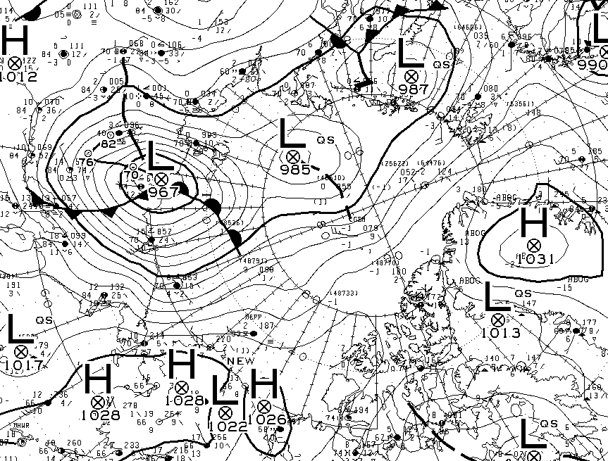
The higher waves and swells have occurred and are forecast to be as high as 2-3 meters near the storm center, which is currently expected to remain about 970-972 millibars in strength for the next 18 hours.

August 28 observation of Arctic SLP and wind flow.

The impacts of wave, wind and ocean warmth are apparent in the August 27 imagery. The "Wrangel Arm" has withered and the breakup of ice extends well into the remaining pack. Additionally the flow along Greenland's coast and into warmer waters by some of the pack will lead to further drops in area and extent through September until the minimum.


The inflow into the storm center continues to draw in warm moist air which accelerates melt. Winds as high as 30 knots are flowing almost to the North Pole, and flushing ice into warmer waters of the North Atlantic.

While it is quite unlikely we will break the 2012 lows, it seems 2016 is on its way to breaking 2007's extent and area hold on second place.


Who knows what the rest of this Arctic melt season has in store, but the mix of higher sea surface temperatures, storms and waves may slow sea ice development and lead to another low sea ice maximum next spring.

Sources: Coral Reef Watch 5km SST Anomaly and Climate Reanalyzer Sea Ice. August 26-27, 2016.
The image gives a glimpse of the global climate "heartburn" this incredible year has brought.
That's interesting hypothesis even though it is wrong. I've already heard such suggestion when I was on Arctic expedition with https://poseidonexpeditions.com/arctic/. But one of our teammates was scientist and he explained why it was wrong.
ReplyDeleteI'am glad to read the whole content of this topic and am very excited.Thank you. For more details about weather Sxm St-Martin
ReplyDelete